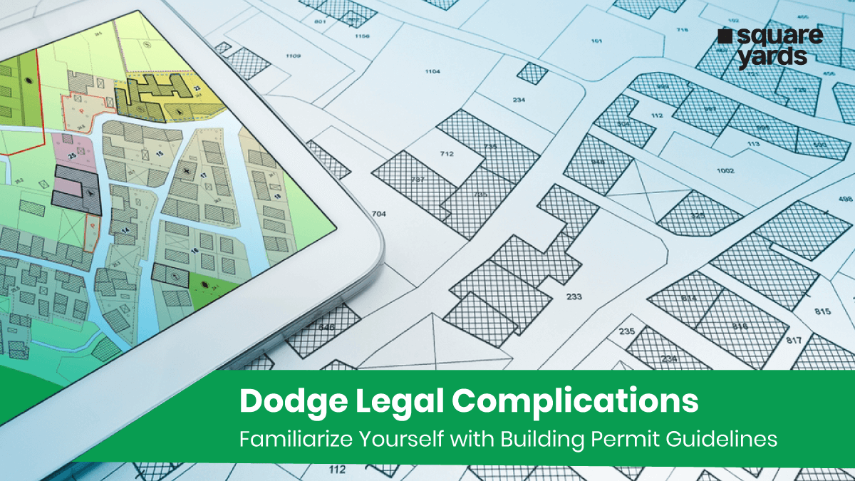
A plat map, sometimes called a property line map, is a detailed drawing that acts like a blueprint for a specific land area. Licensed surveyors create the legal documents filed with local government offices. It includes information about property boundaries, lot dimensions, street locations, and easements, serving as an essential tool in real estate, land development, and urban planning. Plat maps are created by surveyors and are often required for legal documentation, land transactions, and construction projects. They ensure clarity and accuracy in defining property ownership and help prevent disputes over land boundaries.
Ensure you do not misplace your plat map among the jumble of paperwork involved in the closing. It is important to comprehend the purpose of a plat map and how it’s utilised to scrutinise the document properly.
Plat Map vs. Plot Plan: Understanding the Difference!
Examining a plat map and plot plan is important when closing on a property. These maps offer vital information about the property, such as its dimensions and the location in the surrounding area. A plot plan provides a detailed view of your land, showing any existing structures, boundaries, and rights of way. Meanwhile, a plat map offers an overview of multiple plots in a given area, indicating land use and potential for additional structures.
Not all properties are platted, and plat maps can be updated, so it’s important to verify that you’re viewing the most current data. Additionally, while plat maps are sometimes called parcel maps, government entities often use them to identify their boundaries.
When Do You Need a Plat Map?
A plat map is a valuable resource throughout your property ownership, not just when you initially buy it. Here are some key situations where referring to your plat map can be beneficial:
-
- Understanding Property Lines: It provides a clear picture of your property’s boundaries, preventing any confusion or potential disputes with neighbours regarding property usage.
- Planning for Construction or Renovations: A plat map is important if you plan any property additions or modifications. It helps ensure your planned structures stay within your designated lot and don’t encroach on easements or setbacks outlined in zoning regulations.
- Resolving Property Line Disputes: If you disagree with a neighbour about property lines, a plat map serves as legal documentation to settle the dispute.
- Understanding Zoning Restrictions: Depending on the detail, the plat map might indicate zoning regulations for your area. This information is essential for knowing what construction or development is permitted on your property.
- Identifying Easements Impacting Your Property: Easements are portions of your land that others may have legal rights to access, such as utility lines or shared driveways. A plat map will illustrate these easements so you are aware of any restrictions they impose on your property usage.
Understanding Property Encroachment

Property encroachment occurs when a property owner unlawfully extends a structure or uses land that belongs to a neighbouring property. This can happen in various ways, such as building a fence, shed, or driveway that crosses the boundary line into the neighbour’s property. Encroachments can lead to disputes between property owners, as they infringe on property rights and affect the value and usability of the affected land. Encroachments are often discovered during a property survey or when a plat map is reviewed. It is important to address encroachments promptly through negotiation, legal agreements, or, in some cases, court intervention. Resolving encroachments is important to maintain good neighbour relations and ensure clear property boundaries.
Is Property Survey Necessary?
While a plat map offers a valuable overview of your property, it may not always be the most detailed document. Sometimes, a property survey may be necessary to understand your land better. Unlike a plat map, a property survey involves a licensed surveyor visiting your property to take physical measurements and verify the location of property lines. This detailed process can be crucial in several situations. For instance, if you are planning a significant construction project or facing a property line dispute with a neighbour, a property survey can provide the accuracy and legal defensibility needed to move forward confidently.
Types of Plat Maps for Homeowners

While various types of plat maps are used in land development, as a homeowner, you are primarily concerned with the one depicting your specific property and its surroundings. This is typically a plat of subdivision.
-
- Plat of Subdivision: This is the bread and butter for homeowners. It shows how a larger area was divided into individual lots, including yours. It details the property lines and dimensions of each lot and often includes streets, sidewalks, and easements.
- Short Plat: This is used when a single parcel is subdivided into several lots, typically up to four. You might encounter a short plat if your property resulted from such a recent subdivision.
- Plat of Consolidation: This is the opposite of a short plat. It occurs when several neighbouring properties are combined into a single larger lot. You will unlikely need this type of plat map unless you’re involved in a large-scale land acquisition project.
- Amending Plat: This comes into play if the original subdivision plat has been modified, perhaps due to boundary adjustments or corrections. While you might encounter an amended plat if the original subdivision layout was updated, it is not essential for everyday homeowner needs.
- Vacating Plat: This is a rare case where an existing plat map is officially rendered invalid. As a homeowner, you would not typically deal with this.
Key Insights from a Plat Map
A plat map provides a wealth of valuable information about a property, including:
-
- Property Boundaries: Clearly defined lines that indicate the exact borders of the property.
- Lot Dimensions: Detailed measurements of the property’s length, width, and overall area.
- Easements: Areas where rights of way are granted for utilities, access roads, or other uses that may affect how you can use the land.
- Streets and Access Points: Locations of adjacent streets, roads, and access points to the property.
- Neighbouring Properties: Information about adjacent lots and their boundaries, helping to understand the neighbourhood layout.
- Zoning Information: Details about the property’s zoning, which dictates land use regulations and restrictions.
- Improvements: Existing structures such as buildings, fences, driveways, and other improvements on the land.
- Topographical Features: Natural features like hills, valleys, and bodies of water can affect construction and landscaping plans.
- Legal Descriptions: Official property descriptions used in legal documents and real estate transactions.
- Property Boundaries: Clearly defined lines that indicate the exact borders of the property.
Understanding Easements on a Plat Map
An easement is a legal right granted to individuals, companies, or government entities to use a portion of a property for a specific purpose. The type and purpose of the easement determine how it can be used. Here are some common types of easements:
-
- Utility Easement: Allows utility companies or municipalities to access your property to install and maintain essential services like utility poles, electrical lines, water pipes, gas lines and sewer lines.
- Private Easement: This permits another person to use part of your property for a specific purpose. For example, you might grant a neighbour an easement to access a sewer line running through your land.
- Access Easement: Prescriptive easements are frequently utilised for pathways or roads in communities, which allow access to numerous properties.
- Other Prescriptive Easements: These easements grant specific access rights for various purposes, which are clearly defined and legally binding.
- Utility Easement: Allows utility companies or municipalities to access your property to install and maintain essential services like utility poles, electrical lines, water pipes, gas lines and sewer lines.
Interpreting a Plat Map and Determining Your Lot Size
When you receive your plat map, start by finding the symbol legend. This key will help you accurately interpret the map’s details and locate the monuments within your neighbourhood. Next, identify the directional arrow (indicating north) and the scale, usually positioned together in one of the map’s corners. The plots typically appear as rectangular boxes aligned with the roads, each marked with a lot number in the centre. Directly beneath the lot number, you will find the lot size expressed in square feet. The parcel number is displayed in smaller digits within the plot boundary, while the house number is located just outside the plot boundary, along the street line.
In addition to the recorded lot size, you can verify it by calculating the dimensions. The lengths of the boundary lines are noted alongside them within the plot box. Pay special attention to any easements along the boundary lines, including their type and measurements. Understanding these easements is crucial, as they indicate areas where specific rights, such as utility access, might limit your use of the property.
Assessing the Accuracy of Plat Maps
The accuracy of your plat map hinges on its updated version. A map created in the last five years is likely accurate. However, older maps are more prone to discrepancies due to changes over time. Weather events, new structures built by neighbours, municipal alterations to roads or alleys, and modifications by utility companies can all affect the landscape. Given these potential changes, if you have any concerns about the accuracy of your plat map, it is wise to commission a survey of your property. This will provide you with the most up-to-date and precise information regarding your land.
How To Locate a Plat Map For Your Property

Acquiring a plat map can vary based on the type of map you need and your purpose for obtaining it. Here are some common sources:
-
- Local Government Offices: Visit your city records office or the county assessor’s office to request a plat map for properties within their jurisdiction.
- Bureau of Land Management (BLM): For federal lands, you can obtain a plat map from the BLM, which manages public lands.
- Title Company: When you conduct a title search, the title company will often provide a plat map as part of the documentation package you receive.
- Local Government Offices: Visit your city records office or the county assessor’s office to request a plat map for properties within their jurisdiction.
Hiring a Land Surveyor for Exact Boundaries
A land survey is necessary to determine the precise dimensions of your land. The cost of the survey depends on several factors, including the size of the lot, the type of survey required, the terrain, and the intended use of the property. If you purchase a home, your lender may request a mortgage or boundary survey. The mortgage survey will identify the property’s boundaries and structures. Meanwhile, a boundary survey, known as a boundary assessment, will only identify the plot boundaries.
You May Also Read
|
Guide To Home Inspection Contingency |
|
|
Know About Data Distribution Facility |
|
|
What is VOW in Real Estate |
|
|
Understand Real Estate Council of Ontario |
|
|
All About Equity Multiple in Real Estate |
Frequently Asked Questions (FAQs)
How do you see property lines in Canada?
In Canada, property lines can be seen by accessing land registry records through provincial or territorial land title offices, using online mapping services like GeoWarehouse (Ontario) or BC OnLine (British Columbia), or hiring a professional land surveyor for precise measurements.
What is the best property line app in Canada?
LandGlide is Canada's leading and most detailed parcel data and property line mapping application.
How do I get property lines in Ontario?
To get property lines in Ontario, you can access the Ontario Land Registry Office, use online services like GeoWarehouse, or hire a professional land surveyor for precise measurements.
How do you find out who owns a property in Ontario?
In Ontario, you can find out who owns a property by searching the Ontario Land Registry Office https://www.ontario.ca/page/search-land-property-records online or by visiting a local office.